Kīlauea

The volcano known as Kīlauea, on Hawaiʻi’s Big Island, is once again making headlines as one of the world’s most active and compelling volcanic systems. In this article we’ll explore its recent eruptive activity, dive a bit into the underlying science of how it works and how the Hawaiian Islands themselves were built, and look at the historical and cultural significance of this remarkable place.
Recent Eruptive Activity
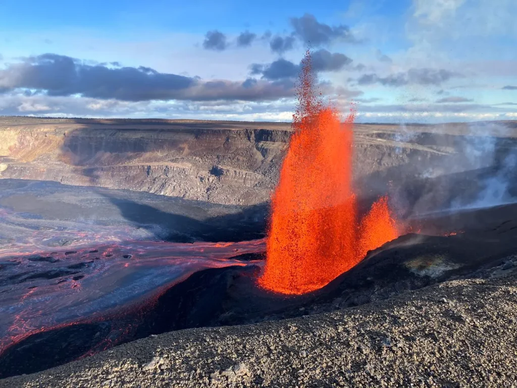
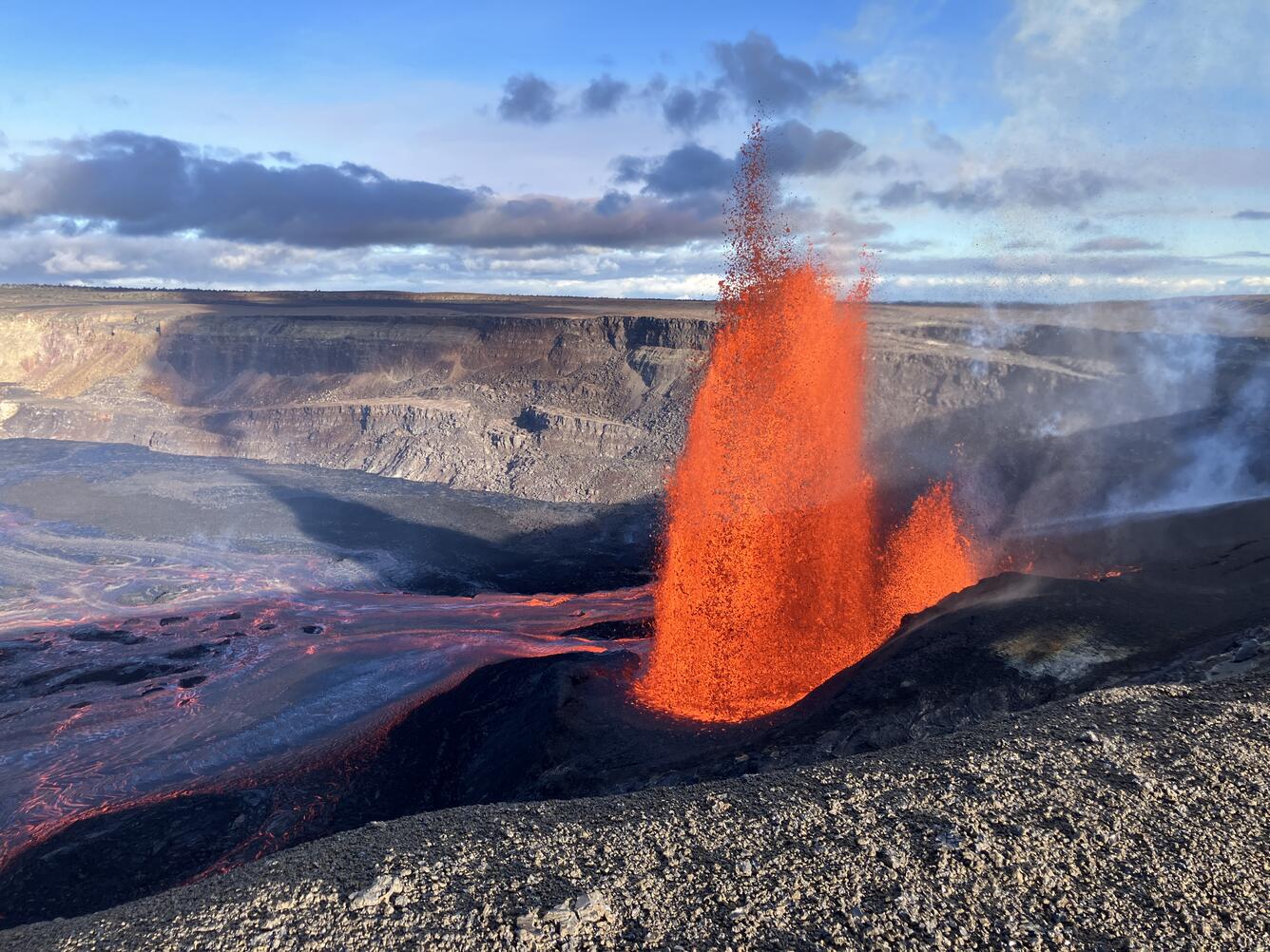
Kīlauea has been in an active phase at its summit region. According to the U.S. Geological Survey (USGS), eruptive activity began on December 23, 2024, within the summit caldera (known as Kaluapele) and episodes of lava fountaining and flows have been accumulating since then. USGS+2USGS+2
For example, on May 25 2025 the volcano produced spectacular lava fountains more than 1,000 feet (~300 m) high, with the plume of volcanic gas and tephra reaching upward of 5,000 feet. Big Island Now
While many might think of volcanoes as unpredictable monsters, this kind of episodic activity is relatively common at Kīlauea: short bursts of intense activity separated by pauses while the magma system recharges. According to USGS: “This pattern of inflation and deflation with every recent lava-fountain episode … indicates that Kīlauea summit has been in some level of equilibrium since the eruption began.” USGS+1
That said, volcanism always carries hazard. Even though the activity is confined within the national park and away from major towns, visitors and locals must still contend with gas emissions (notably sulfur dioxide), tephra (including “Pele’s hair”—fine strands of volcanic glass), and the potential for sudden change. USGS
Volcano Science: How Kīlauea Works
To understand why Kīlauea behaves the way it does, we need to look at several features of its volcanic system.
1. Shield volcano and magma source
Kīlauea is classified as a shield volcano. That means it has broad, gently sloping sides rather than the steep cone of a stratovolcano. This form is a result of the kind of lava it produces: fluid basaltic lava that flows relatively easily, creating wide spreads rather than steep piles. vulkane.net+1
The magma rises from deep in the Earth’s mantle, and Kīlauea lies over a hot-spot in the Pacific Plate. The magma supply and plumbing system allow for repeated volcanic episodes rather than a single catastrophic blast (though explosive events are not unheard of). USGS+1
2. Rift zones and summit caldera
The volcano doesn’t just erupt at the summit; it has prominent rift zones — the East Rift Zone and the Southwest (or Lower) Rift Zone — where magma can migrate sideways and erupt from fissures far from the summit. In fact, most of Kīlauea’s flank eruptions occur along these rift zones. National Park Service+1
At the summit the caldera known as Kaluapele, and within it the pit crater Halemaʻumaʻu, is the focal point for the current activity. During eruptive phases, the lava fountains and flows fill and reshape the crater floor, the ground tilts and deforms, and seismic unrest and gas release increase. USGS
3. Eruption types: effusive vs explosive
Kīlauea’s signature eruptions are typically effusive — meaning the lava flows out rather than violently exploding. However, under certain conditions it can switch to explosive behaviour (for example if groundwater interacts with magma, or if there’s a collapse of a caldera allowing gas-rich magma to decompress). One historical example is the 1790 eruption, which killed hundreds. Wikipedia+1
The 2018 eruption on the East Rift Zone exemplifies how Kīlauea can rapidly change behaviour. Magma intrusion caused slope collapse and massive lava flows; the summit caldera collapsed deeper. recovery.hawaiicounty.gov+1
4. Monitoring and early warning
Thanks to improvements in geophysical monitoring (seismic networks, tiltmeters, gas sensors, satellite imagery), scientists are able to observe signs of magma movement, inflation/deflation of the ground surface, gas emissions, and seismicity. These give clues to what may come next. For example, tilt instruments record changes in ground shape — inflation when magma accumulates, deflation when magma is released. The USGS notes these “saw-tooth” patterns at Kīlauea’s summit in recent episodes. USGS
Deep-learning and advanced imaging techniques are also being applied to Kīlauea to better understand collapse sequences and magma chamber dynamics. arXiv+1
A Brief History of the Hawaiian Islands & Kīlauea’s Role
The story of Kīlauea cannot be separated from the larger story of how the Hawaiian Islands were formed.
Origin of the islands
The Hawaiian Archipelago is created by a volcanic hot-spot beneath the Pacific Plate. As the plate moves (west-northwest) over the hot-spot, magma rises, and islands form one after another. Over millions of years the older islands erode and sink, while newer islands build up.
Kīlauea sits on the southeastern part of the youngest main island, Hawaiʻi (often called the “Big Island”). Volcanic deposits from Kīlauea cover 90 % of its surface with flows younger than 1,000 years. Wikipedia+1
Kīlauea’s eruptive history
Kīlauea has an extremely active record. Since written documentation began, it has erupted dozens of times. From 1952 onward, many eruptions occurred at either summit or rift zones. Between 1983 and 2018 the East Rift Zone experienced nearly continuous eruptive activity. USGS+1
Some key historical points:
-
The 1790 eruption (Keanakakō‘i event) at the summit was explosive, depositing ash and killing more than 400 people — the deadliest volcanic event in what is now the U.S. Wikipedia+1
-
The 2018 eruption: Beginning May 3, 2018, in the Lower East Rift Zone (Leilani Estates subdivision), following the collapse of the Pu‘u ‘Ō‘ō crater floor, resulted in lava flows, caldera collapse and major land change. recovery.hawaiicounty.gov
-
The ongoing summit eruption cycle that began December 23, 2024 is a reminder of how dynamic the system remains. USGS+1
Cultural and historical significance
Beyond science, Kīlauea has deep cultural significance to Native Hawaiians. Its summit crater Halemaʻumaʻu is traditionally considered the home of the goddess Pele, deity of fire, lightning, wind and volcanoes. Wikipedia
The formation of the islands themselves is woven into Hawaiian myth and oral tradition, much of which reflects the volcanic processes in play. The land is seen as alive, being created and reshaped. Kīlauea’s frequent activity reminds Hawaiians of the island’s youth and ongoing birth-process.
Why It Matters & What’s Next
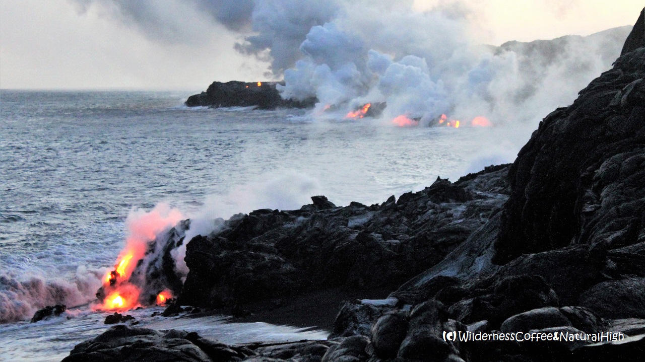
Kīlauea is more than a tourist attraction: it plays a vital role in shaping the landscape, ecology and human settlement of Hawaiʻi. Each eruption adds new land (lava flows extending into the sea), alters the coastline, affects air quality (vog), and poses hazard to communities.
For science, Kīlauea is a natural laboratory. Its frequent eruptions and relatively accessible monitoring infrastructure mean volcanologists can study magma dynamics, eruption precursors, collapse mechanisms and the interplay of rift zones and the summit. For example, studies of the 2018 collapse sequence help inform how calderas may behave elsewhere. arXiv+1
Looking ahead, questions remain: Where exactly will magma next erupt (summit vs rift zone)? How much buildup is occurring underground? How long will the current summit phase last? Will the system once again shift to a flank eruption? Monitoring data on ground inflation, gas release, seismicity, and deformation are keenly observed.
Visitors and residents must always be mindful of risks: ground instability in crater areas, toxic gases, falling tephra, laze (lava + seawater chemical reactions) if flows reach the ocean, and the fact that even seemingly quiet periods may abruptly change.
In Summary
Kīlauea is a spectacular example of active volcanism, island-building in real time, and the intersection of culture, science and nature. From its molten fountains to its deep magma chambers, from the shield-volcano slopes to the rift-zone fissures, it reminds us that the Earth is constantly in motion, remaking land and life. Whether you’re drawn by awe, by scientific curiosity, or by cultural significance, Kīlauea offers all of that — and continues to write new chapters in its fiery story.